Hiking the Pouakai Circuit: 3 Amazing & Varied Days in Taranaki
It all started a year ago with a walk around the river in Cambridge while training for the Milford Track. Our friends Jackie & Heidi were visiting from Wellington, and we got chatting about doing a multi-day hike together the following summer with our kids (aged 15 and 12) who had never even been on an overnight hike let alone a multi-day hike. After some discussion, we settled upon Lake Waikaremoana as a suitable Great Walk with fairly easy logistics for the six of us to get to from both ends of the island.
Late in 2021, it became apparent that hiking at Lake Waikaremoana was not going to be possible, with much publicity in the news about the state of the Great Walk becoming quite rundown and the local iwi wanting to keep as many people out of the area as possible due to their low COVID vaccination rates. So a new plan was hatched. Clearly we couldn't do many of the other Great Walks, they were all pretty much booked out for the season, especially as we wanted to walk in early January, during prime summer holidays. We wanted a walk that wasn't too challenging and somewhere we could ideally meet in the middle, so we settled on the Pouakai Circuit being a good replacement at 3 days and 25km total hiking, albeit on a track rated 'advanced' by DOC. But with a long period of hot and dry summer weather in the lead up to our hike, we felt reasonably confident that the track would be about as easy as it ever gets, so off we went!
What & Where is the Pouakai Circuit?
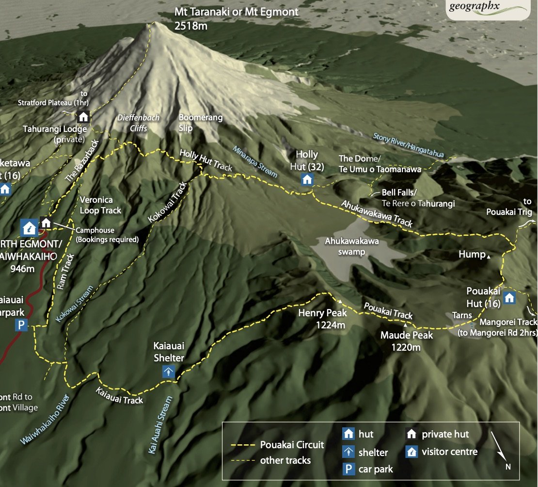
The Pouakai Circuit is a 3 day, 25km circular track which starts and ends at the North Egmont Visitor Centre on Mount Taranaki - its name taken from the Pouakai range where you spend Days 2 and 3 on the hike. This is not to be confused with the Pouakai Crossing which is a 1 day, 1 way 19km hike which takes in a good chunk of the same tracks, except instead of returning to North Egmont (on what is the most challenging part of the circuit on the Kaiauai Track), you carry on down to Mangorei Road on a much gentler track which is mostly boardwalk and steps upon departing from Pouakai Hut.
Whether you choose to do the Crossing or the Circuit will depend on the time you have available and whether you want to spend a night or two on the mountain. The days hiking the Circuit aren't long, 4 hours, 2.5 hours and 4.5 hours respectively so you could absolutely hike this as an overnight hike, and it can be walked in either direction. For us, with teenagers who had never done a hike before, we were happy to take our time and not push too far too fast, and just soak up the experience of being in NZ's back country.
The two huts that you stay in are Holly Hut (32 beds) and Pouakai Hut (16 beds). It can be challenging to get a booking for Pouakai Hut as it is within easy reach of the road end and is a popular spot for photographers to stay overnight to get the famous tarn shot (I know as I'd done it twice in the past!).

So if you are struggling to get a booking at Pouakai Hut, you can easily turn it into a 2 day hike by only staying at Holly Hut. On our hike, there were only 10 people in total staying at Holly Hut but Pouakai Hut was completely full with all 16 beds taken.
How Hard is the Hike?
I personally think that Days 1 and 2 (in the direction we took) would be better rated as Intermediate, they're comparable to the Great Walk tracks like the Milford Trackand the Routeburn Track. It's really only the last day coming back via the Kaiauai Track that feels more advanced, due to the steepness of the ascent to Henry Peak and immediate sharp descent through roots and step downs in the forest. It was dry when we hiked itm but I can imagine it wouldn't be much fun in the wet with mud and slippery roots to negotiate. There are also about 5 wooden ladders to climb up on the ascent of Henry Peak, as well as one metal ladder to descend in the forest and 2 swing bridges to cross.
The track profile shows about 1,300 metres in total elevation gain over the 3 days, almost a similar amount each day, it's really only the last day that has a particularly steep descent.
What facilities are at the huts?
I've certainly been spoilt in the past with the Great Walk hut facilities, having gas cookers and flushing toilets. The two huts on the Circuit are far more basic with outdoor taps only for running water, and long drops with not a speck of toilet paper in sight - thank goodness we packed a toilet roll at the last minute thinking we would only need it for any on-track emergencies. Both huts have heating (in the form of a woodburner) but we didn't really need heating with it being midsummer.
In terms of water, there are the usual DOC signs warning you to boil the water before use. We didn't, but that was more because we only had one small kettle between four of us. Another thing to note is that there really wasn't anywhere on the hike to fill up with water along the way, so you really do need to carry as much water as you will need from the hut each day.
Where do you leave your car while hiking?
You can park your car at either North Egmont Visitor Centre or at the end of the Kaiauai Track - though there are only 5 carparks here. We chose to park in the main carpark, but arrived early at 7am to ensure we could get a park since it was a bluebird summer Saturday morning with plenty of people attempting to climb to the summit of Mt Taranaki. At the end of the hike, we sent 2 of our party back up the road without their packs to get our cars (approx 2km, 30 min walk up the road) while the rest of us just waited at the track end.
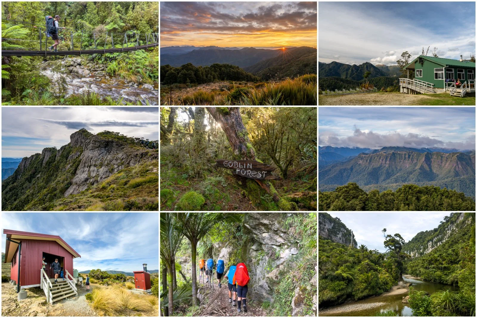
Day 1: North Egmont to Holly Hut (4 hours, 9.2km, 450m elevation gain)
The first half an hour of the track will have you huffing and puffing up a heap of stairs until you emerge to the first lookout point. You'll be amazed (as we were) just how far away the carpark already looks from here, and if it's a fine day there are incredible views across to the mountains of the Central Plateau in the distance some 150km away, as well as up the Taranaki coast.


It's not much longer until you reach the narrow, gravel area known as The Razorback, which is in fact the highest point of the whole hike, amazing to think you're there only 45 minutes into the hike. One of the things I loved about hiking this first day was that you could often see the track disappearing far off into the distance - always nice to know where you're headed, I chose to focus on that rather than thinking how far away it looked!
From here you sidle under Humphries Castle (there's a junction here for a track which will take you left over towards Tahurangi Lodge), and at times when we looked up we could actually make out summit hikers climbing on the scree slopes high above us.
There is plenty of variation on Day 1 of the track with a few interesting sections with stairs and rocks to clamber over - it definitely kept the day from being boring!

After turning right, the track sidles along under the Dieffenbach Cliffs and around several ridges including a crossing of the infamous Boomerang Slip - a giant permanent scar on the mountain's landscape. It was here that we came across a group of workers upgrading the track - eventually this track will form part of a mega Taranaki Crossing that you can hike all the way from Mangorei Road to Dawson Falls.
It was interesting to hear the workers say they have to hike for 1.5 hours just to get to work each day, before they then have to do the hard yards building steps and improving the track. We saw several helicopters dropping off and picking up wood to different points on the track, and one even carrying a portaloo - that's not something you see every day out hiking!
The section crossing the Boomerang Slip was probably the part we had to most take our time over, it's nothing too arduous but you do want to make sure of your footing on the loose scree.


Eventually we reached a natural junction where the alternative Kokowai Track comes up from the lower carpark, this is the route you must take in the event the Boomerang Slip is impassable, as happened a few years back. From here the vista changes when you turn the corner, and you can suddenly see the Ahukawakawa Swamp and the whole Pouakai range laid out before you - it's inspiring being able to see where you'll be hiking over the next two days.

Panoramic view of the Pouakai range and Circuit Route for next 2 days
As you begin to descend, the track turns to more boardwalk and steps - which might sound like easier going but it does get a bit monotonous after a while, and with the day beginning to warm up this was about the only time I felt like my feet were getting hot and sweaty enough for blisters to form.
The turnoff to Holly Hut is only about 5 minutes before the hut, and there is the Minapara Stream to cross which can become impassable after heavy rain, but it was completely dry as we clambered past over the dry rocks in the stream bed. And at about exactly 4 hours in, we reached the hut. The hut is situated in a lovely clearing, with views to the summit of Mt Taranaki - what a gem of a spot!

Side Trip to Bells Falls (1 hour return, 3.3km, 150m elevation gain)
Depending on the weather and how spritely you're feeling after that hike, you can also take a wee side trip down to Bells Falls. There are great views out towards the western coast of Taranaki, and lush forest to enjoy along the way. It was such a bluebird day when we were there that I didn't really feel I could do justice to the waterfall (I far prefer moody, cloudy days for waterfalls) but it was still a beautiful spot to see and worth the extra trip.

We sat outside the hut enjoying the scenery in the late afternoon sun, and were very surprised that we only had to share the hut with four others that night, it certainly added to the serenity of the experience.
Day 2: Holly Hut to Pouakai Hut (2-2.5 hours, 5km, 350m elevation gain)
Since this is a much shorter day, you could also choose to do the Bells Falls trip on this day before heading off to Pouakai Hut. The hike today isn't long, but there's still a decent hill to climb after meandering through the Ahukawakawa Swamp. We'd have liked the swamp section to last a lot longer as we really enjoyed the LOTR feel of the place. The boardwalk through the swamp is a recent addition, and this certainly speeds up the walk and keeps your feet dry too!

The climb up the ridge out of the swamp is again a lot of stairs and really gets the heart racing very quickly. It was at this point that we ended up in the clouds with much less visibility. We did however catch a glimpse of Holly Hut far away in the distance, before we succumbed to the clouds.


The landscape changed quite frequently as we climbed higher and higher, with little glimpses of otherworldly forest and ferns amongst the more often barren looking landscape.

We reached the hut by 11am, and had a whole day to chill, enjoying games, puzzles and the odd glimpse down to sea level when the clouds obligingly parted. This hut is quite busy during the day with day hikers coming up and back from Mangorei Road and choosing to use the hut as a place to stop and eat and have a break.


I'd been checking the weather forecast all day and it looked possible that the clouds might lift a bit around sunset, and sure enough they did. The wind didn't abate though! We took a short 5 minute hike up to the ridgeline to see if Mount Taranaki was visible, and it was - kind of, wearing a golden cloud cap across the top. The wind was pretty ferocious though so we only stayed long enough for a couple of shots before retreating back to the comfort of the hut.


Day 3: Pouakai Hut to Kaiauai Carpark (4.5 hours , 11.5km, 480m elevation gain)
Allow an extra 2km and 30 minutes to get back to North Egmont Visitor Centre via the road
The wind and cloud were not about to relent so we decided we'd make tracks early from the hut, leaving at 7.30am. We also had no idea exactly how long this day would take as we'd heard varying reports of 6-8 hours (and we had 3-5 hours of driving home straight after finishing), so there was a bit of trepidation ahead about how tricky the track would be.


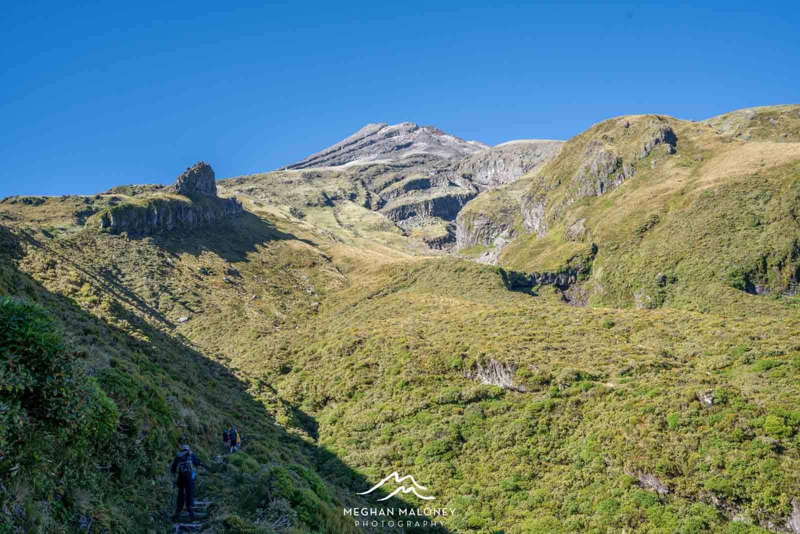
After walking along the ridgeline past the tarn (boohoo no reflection today!), it wasn't long before reached the climb up to Henry Peak. At this point the wind was howling and the clouds were racing, so we just got stuck into the climb up the 5 wooden ladders and before we knew it we were at the summit. Surrounded by cloud. Oh well, one can imagine the views, and the sign at the top tantalisingly reports views in all directions from here. Never mind.

From here, it is a steep descent of 500 vertical metres over 3km - firstly down hundreds of wooden steps, before giving way to a rooty track through the forest, which is no less steep I might add but does make a change from the monotony of the steps!
I can imagine that this day would be not much fun in the wet, as roots are notoriously slippery to step on so I'm very grateful that we didn't get any of the predicted rain on this trip.

There's one more unexpected metal ladder to descend and quite soon after you cross the Kaiauai Stream via a swingbridge. After this, the track then ascends back out of the valley for another hour or two towards the road. The last big challenge is an even narrower swingbridge high over the Waiwhakaiho River - enough to make anyone not great with heights have a little heart flutter anyway.

We reached the end of the track exactly 4.5 hours after starting, so the signposted time was exactly correct - though if you are walking in the opposite direction it says it's a 6 hour climb to Pouakai Hut - which I don't doubt!

Final Thoughts
Even though I went into this hike a little nervous how my kids would find it and whether we would cope with an advanced track, they walked a whole heap faster than I did, and spent a good amount of time waiting for their mama to catch up. I'll blame the fact that I was taking photos on my speed, but really it's just because apparently I walk quite slow! In any case, we all thoroughly enjoyed this hike. There is such an amazing variety of scenery over the three days, it really has a little bit of everything. Alpine tracks high up a mountain, a waterfall, lush NZ forest, a swamp, lots of stairs for a good heart workout and a few more challenging sections to negotiate along the way.
It's not easy to get 3 days in a row of good weather on Mount Taranaki, it is notorious for keeping its head in the clouds for days on end, so even getting one day with incredible views is such a bonus, and I'm grateful.
And I hope that if you hadn't heard of the Pouakai Circuit or thought it was a hike you could complete, it will now be firmly on your wish list!
For more NZ Hiking Guides, check out the guides below:
9 Tips for Hiking the Routeburn Track