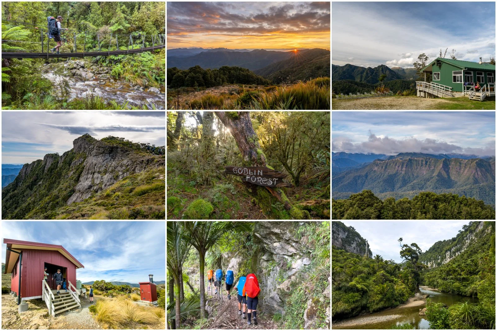
Hiking the Milford Track: NZ's Greatest Walk
The Milford Track is often described as one of the world's best multi-day hikes, and tickets for the Great Walk summer season, which runs November to April, usually sell out in minutes when they are released six months in advance!. I grew up hearing tales of my Dad walking this hike with his father back in the 1970's so it had long been on my bucket list.
With international borders shut due to COVID-19, there was never going to be a better time to hike than in the 2020/21 season, and after convincing two of our best friends to join us, we managed to secure tickets (just!) for the last week of the season. We now had a grand adventure to look forward to, and so spent the summer undertaking practice hikes in the heat. But how would this compare to walking in potentially near-winter conditions in late April? We would find out!
If you're interested in more detailed tips on logistics and preparation, also read my Getting Prepared for the Milford Track Tips post.
Milford Track Day 1
Te Anau Downs to Glade Wharf (via Real Journeys boat transfer)
Although the track officially starts when you reach Glade Wharf, the hour's boat ride across Lake Te Anau is worth a mention. It's incredibly scenic, and depending on who you travel with, you may learn some interesting facts about Fiordland before you even begin the hike. For example, did you know that Lake Te Anau is the largest lake by fresh water volume in Australasia? And it is the only place in NZ with inland fiords - the arms of the lake are named South, Middle and North Fiord. It is also incredibly deep, at its deepest it reaches 417 metres and partially lies below sea level - making it a crypto-depressant lake. What I also found interesting is that the closest land mass to the west of Milford Sound is South America! When you think about how close South America is to the east by contrast, then it's mind boggling to think it's also the closest land mass to the west all the way around the other side of the world. Fiordland is also situated at 45 degrees latitude, halfway between the Equator and Antartica, so it's the perfect place for storms from the arctic and tropics to meet - no wonder they slam into Fiordland with the force they do! Think of the Amazon rainforest, you'd expect it to have high annual rainfall and it receives up to 3 metres per year - but this is still only 1/2 of the annual rain fall that Milford Sound gets!

Our 30km journey up the lake was bracing - there was a strong wind, and the mountains were looking misty and broody as they drew us into their grasp. The closer we got to the start of the track, the moodier the sky became, a sign of things to come!
Glade Wharf to Clinton Hut - 5km, flat (1-1.5 hours)
We started our walk in a light rain, so the rain jackets and pack covers got a workout from the start. After passing Glade House where the guided hikers stay, we crossed the Clinton River, the first of many river crossings on the track.
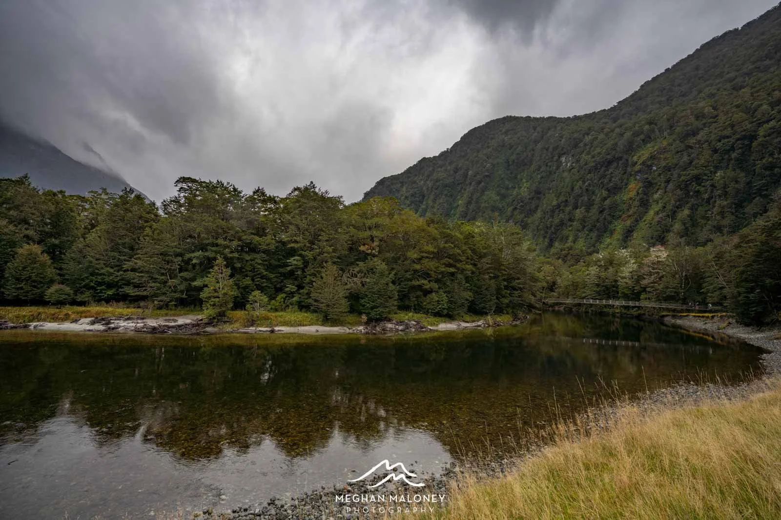

I couldn't believe how green yet clear the water was here! After crossing the bridge, the rain gradually got heavier. This part of the track is easy and flat, and it's not long to reach Clinton Hut, but just before you reach the hut there's a 2 minute detour to a wetland walk and viewpoint - we couldn't see very far in the rain, but the boardwalk and colourful moss on the ground was fairytale-like and worth the detour.

Clinton Hut was a welcome sight and we were quick to shed our wet gear and find a bunk. The fire was roaring in the dining room, and although we weren't terribly cold and wet compared to the days to come, it was nice to feel the warmth. During summer months when there are more daylight hours (and I'm guessing when it's not so wet), the rangers will take you on a nature walk around the hut vicinity, but being late April it was dark not long after we arrived. There are also glow worms about a 5 minute walk down the track, but in the rain and dark we opted to stay in the warmth of the hut for the night.

Ranger Ross came in at 7pm to give his hut talk - having experienced these nightly chats on the Routeburn Track I was looking forward to this, as I just love hearing the history and information on flora and fauna that you won't read in a track pamphlet. One of the things that Ross spoke on at length was the incredible pest control work that has been undertaken on the track. In the year 2000, there were only 9-10 pairs of Whio (NZ's rare blue duck) in the area, and with the 2000 stoat, ferret, weasel and possum traps that are regularly maintained on the track, the birdlife has bounced back significantly. The last survey counted up to 90 pairs of whio in the area which is a tenfold increase. Ross talked about how the contractors will now clear 400 traps and only find 3-4 stoats, and where they might have caught 20 possums a week, now it's almost none. It was so heartening to hear this success and the fact it was a real possibility now to see so many different birds on the track: robins, bellbirds, kea, kereru, tomtits, kakariki, rifleman, moreporks, weka and more. We would experience the amazing forest alive with bellbirds the following morning for ourselves!
Milford Track Day 2
Clinton Hut to New Mintaro Hut - 17km, flat to 500m elevation (6-7 hours of walking)
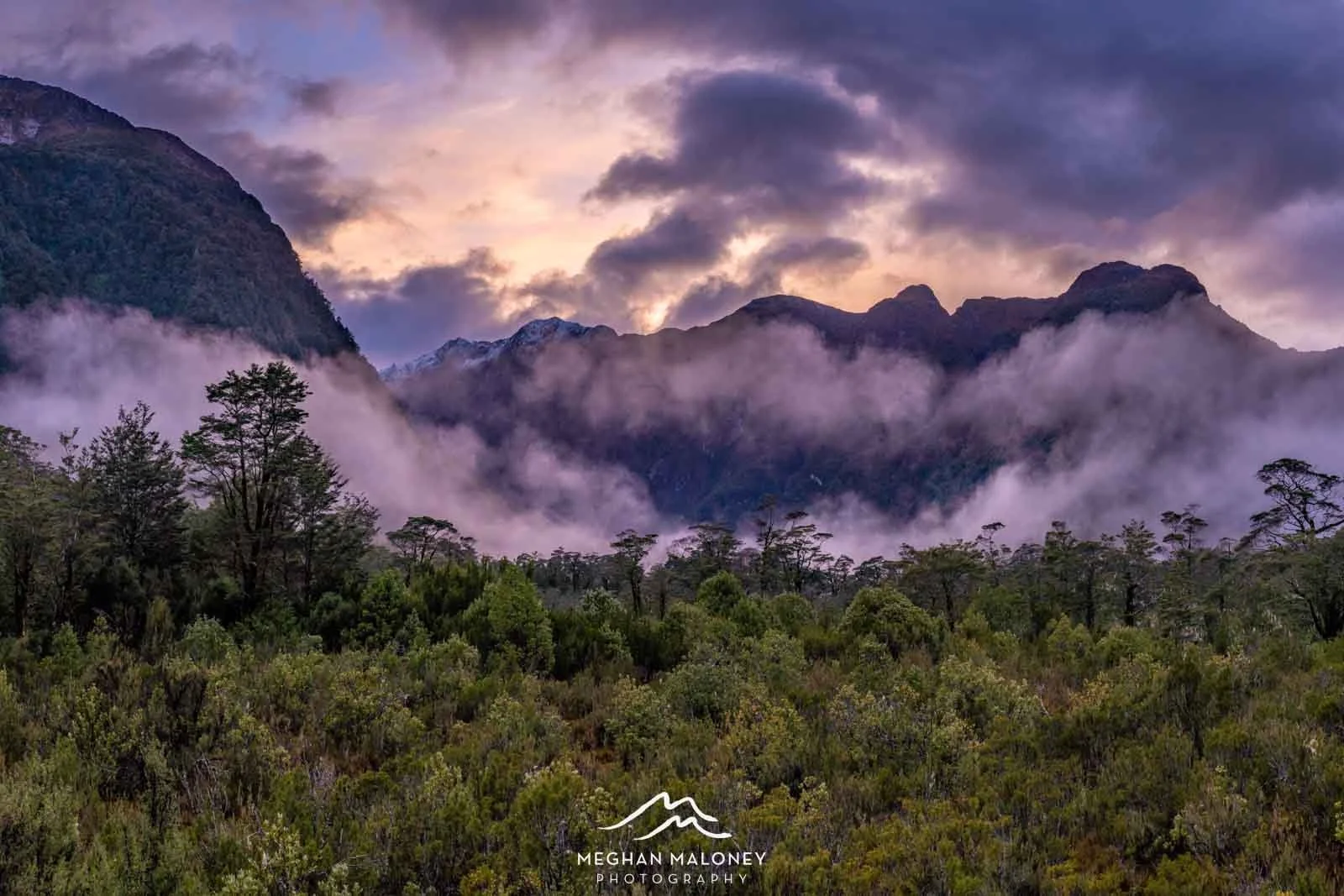
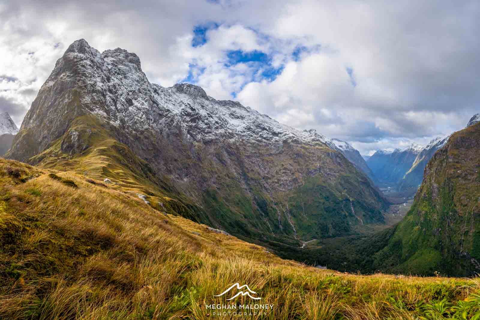
We woke early to a misty, yet colourful view of the Clinton Valley as the sun rose, and it looked like a fresh dusting of snow on the peaks. The best place to shoot sunrise turned out to be the helicopter pad tucked in behind the hut as it had an open view of the whole area, it was hard to pull myself away, but we had a big day of walking ahead.
We set off around 8.15am, and headed up the valley. We followed the river for about half an hour before coming to a lovely clearing with views up and down the Clinton River, amazingly it wasn't raining at this point so we had the chance to fill up our water bottles with refreshingly cold water.

Just after this, we walked past the fork in the river where the west and north sections of he river merge, and had our most spectacular birdlife encounter of the trip - the forest was deafening with the sound of bellbirds while robins happily hopped around our feet. Then the rain set in for an hour, so it was head down to concentrate. As we came upon the widening valley, the rain abruptly stopped and the clouds cleared - and OH MY WORD, the atmosphere!

We took a short detour to Hidden Lake which was SO worth doing - we happened upon a small tarn beside the track with the most incredible reflections of the mountains and mist looking all the way up the valley - I stayed here for quite some time shooting, finding it to be more impressive than Hidden Lake itself.

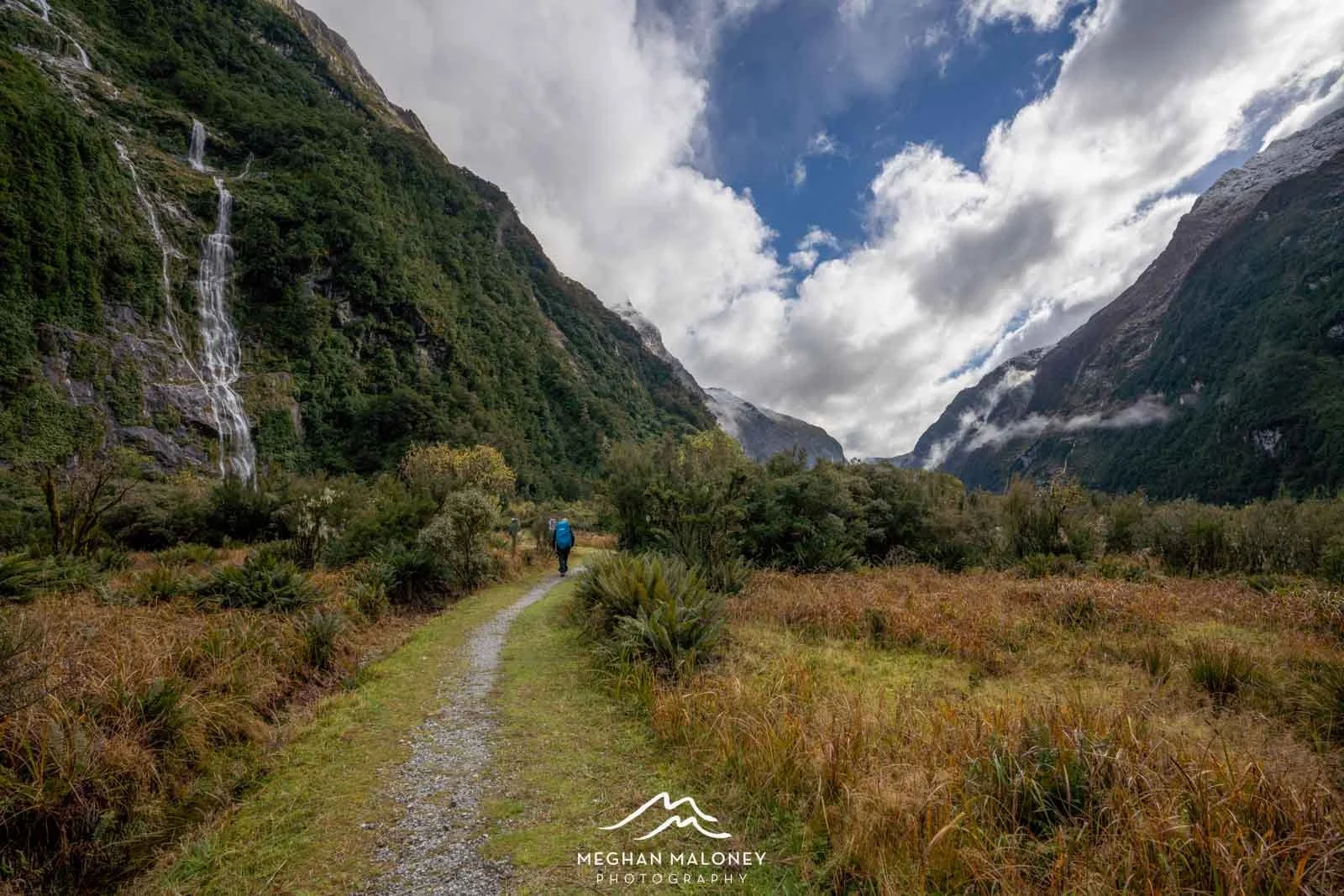
The next couple of hours walking up the valley was one of the most enjoyable parts of the track for me - here we were with 1,000 metre high mountains towering over us on each side, and waterfalls pouring down the cliffs after the rain, and low misty cloud adding a sense of magic to the view. Wow.
We eventually stopped for lunch about 12.30pm after reaching the Prairie Shelter Hut - from here we could see all the way up to the top of Mackinnon Pass where we would be headed the following day - it was awe inspiring, if a little daunting, knowing we had to climb up there!

Not long after leaving Prairie Shelter, the landscape changed and the track became less wide and easy, and more of a hiking track. We crossed over boulder beds and rivers, and wound our way back into the forest, gaining elevation with each step. By 2pm the rain had returned and would remain, but it didn't matter so much in the forest where we were a bit more sheltered.


What we didn't know (until we collected our hut tickets at Te Anau) was that a brand new Mintaro Hut had opened two nights earlier so we were literally only the 3rd group ever to stay in the new hut. DOC have built the new hut slightly further up the valley in a location that has much less earthquake and avalanche risk. Whilst I was very happy to have the opportunity to stay in a brand new facility, I was not too impressed when after almost 8 hours on the track, we came upon a sign that said '15 more minutes to New Mintaro'. The hut ranger must have faster legs than me, because it was more like half and hour and two river crossings later before we actually caught sight of the new hut nestled in the trees, by which stage I was a bit over it!

Thankfully, seeing this awesome new facility with brand new bunk rooms and beds perked me up a bit! The rain had REALLY set in by then so it was a relief to be indoors in the warmth. Ironically, the only thing that wasn't working in the new hut was the lighting so all 40 hikers had to make do with torches to cook dinner and make conversation until Simone, the hut ranger came in at 7pm for her hut talk.
Simone turned out to be just a young girl, and I admired her hugely for being in charge of a hut and track maintenance in what must be one of the more remote and unforgiving locations around New Zealand. Climbing up to the Pass the following day, I could see the effort that was involved to keep the track in order so I really take my hat off to her. Simone was a good storyteller, as these rangers tend to be, and one story of the kea in particular stuck in my mind. It turns out that our cheeky kea friends have been known to access the long drop toilets through the vent shafts on the roof and have been known to accidentally fall down into the piles of poo at the bottom. The tale is told of one unsuspecting tourist who went to lift the lid on the long drop only to have a kea covered in shit fly out at her from the bottom of the long drop - hahahahaha! I think you would be scarred for life after that!
The forecast Simone delivered for the next day was fairly similar: snow, wind and rain, which didn't bode well for seeing any views at the top of Mackinnon Pass. It was early to bed (well 8.30pm) after what had been a very long day, and listening to the rain and wind outside as I fell asleep, I offered up a prayer for a miracle to happen.
Milford Track Day 3
Mintaro Hut to Dumpling Hut 14km (500 metre ascent, 1,000 metre descent) 7 hours
Plus a 5km return side trip to Sutherland Falls approx 5km 1.5 hours
The weather was still pretty bleak when we woke, filling up with coffee and a hot Radix breakfast was a good start before heading out into the elements. We left at 8.15am again walking straight out into heavy rain. Needless to say, we were pretty wet within minutes of starting our climb through switchback tracks heading ever higher through the forest. Waterfalls were pouring off the sides of the track around us, which added an extra element of care as we made our way up the Pass. Simone had given us a great piece of advice - 'when you reach the edge of the tree line you should stop and put on an extra layer of clothing'. I'll admit when we got to this point I was warm from climbing and didn't feel much like adding any more clothes - but I'm so glad I did as the temperature dropped a few degrees and the wind got up within minutes of reaching the open, and I was instantly grateful for the advice.

Amazingly, once we were above the tree line the rain stopped, and the visibility improved. And without too much more walking, the top of the Pass came into view. We were treated to unlimited visibility in both directions, all the way down the Clinton Valley we'd walked the day before, and all the way down the Arthur Valley that we would be descending to after the Pass. I COULD NOT BELIEVE IT.

Sure it was pretty cold up there, and intermittently sleeting at times but the atmosphere with the moody clouds, the fresh snow on the peaks, and sunlight breaking through every so often to light up the scene, it felt like my prayers had been answered in spades!

The monument at the top of the Pass recognises the extraordinary achievement of Quintin Mackinnon who found a way over the pass in 1888, and I'm in awe of those early explorers, and all they had to endure to forge a way for thousands to follow over the next 130 years.

From the monument, it's about another 20 minutes to walk across to the Mackinnon Shelter, and we were ready to be inside in the relative warmth, though we could still see our breath inside so I doubt it was much above zero degrees in the hut, but at least we were out of the wind.

The shelter has gas cookers so you can make yourself a hot drink, and learn about the history of this spot. There have been four previous shelters over the years, and the fifth and newest version of the shelter is only 10 years old. Previous versions of the shelter have been eventually destroyed by the elements - particularly the high winds that rip through here - you actually cannot attempt the walk over the Pass when the winds reach dangerous levels - a call that Simone (or the other Mintaro Hut wardens who take turns working in shifts there) must make on behalf of the day's hikers.

It was so hard to leave these views, but after spending an hour up the top of the Pass we really couldn't put off leaving any longer - there were still many more kilometres to travel and only so many daylight hours left. Reluctantly, we began the start of our 1,000 metre descent into the valley. In the course of the next hour as we descended below the Jervios Glacier, we had intermittent snow and sunshine, and it's in this valley that if conditions dictate you may find yourself having to take the shorter, but much steeper emergency track to avoid the avalanche risk that exists under the glacier, not a problem for us though.

After an hour of enjoying the views of the peaks surrounding us, we entered the tree line again. This took us down a vast section of staircases beside Roaring Burn, a series of cascades and waterfalls that drop steeply into the valley. Sadly, the rain was back by now and the day was marching on or I would have liked to pause longer here. We took a brief stop at Anderson Cascades (by now it was 1.30pm and we'd already been walking for 5 hours), before continuing our journey down through the forest towards the Quintin Day Shelter. I really loved walking through this section of forest, it was magical and if I'd had more time I certainly would have loved to stop and photograph it properly!

We finally reached the Quintin Shelter around 2.45pm, and dropped our heavy packs to head off on the 1.5 hour return walk to Sutherland Falls - NZ's most accessible tallest waterfall at 580 metres. For a long time it was thought to be the tallest, but there are several others in Fiordland that top it, though none of them as 'easy' to get to as this. 'Easy' being the operative word - when you're part way through a multi-day hike haha! I do have a bone to pick with Simone who promised that this side route was a relatively flat, easy walk - I found it far from it! After descending almost 1,000 metres from the Pass, I wasn't super pleased about having to climb a whole lot of steps and travel over a very undulating track to reach the falls - we must have gained another 200 metres or so in elevation on the way there which of course we then had to descend again on the way back.

Sutherland Falls are without a doubt INCREDIBLE to witness. It's hard to do justice to this place with any camera or video footage from down below, I am really glad to have also laid eyes on it up close after seeing it from the air a couple of times during scenic flights to Milford.

By the time we left the falls it was 3.30pm, and we still had almost two hours of walking still ahead of us. Once we picked up our packs, we knew it was all downhill to Dumpling Hut but we were still keen to reach the hut before it got dark. It still felt like a long hour of walking since we'd been on the go 9 hours by the time we eventually reached the hut - what an epic day though!

Ian (the Dumping Hut ranger) started his talk a bit later that night at 7.30pm to allow for the stragglers to make it to the hut - some had arrived a good hour and a half after us so they would have been walking a fair way in the dark. His talk focused on what to expect the following day on our walk down the valley to Sandfly Point - the finishline. It was great to get a blow-by-blow of the timings as well as some of the highlights we could expect to see on the 18km journey. He also pointed out it would be important to keep track of our walking times if we needed to reach the boat transfer by a particular time - important for those who had onward bus connections back to Te Anau or Queenstown.
Once again the forecast was sounding awesome - showers, cold winds and thunderstorms. By this stage though, I didn't particularly care as my prayers had been answered - we'd seen all the best views at the Pass AND we had a hot shower and a luxurious stay in Milford Sound Lodge waiting for us when we finished. Day 4 on the Milford Track is prone to serious flooding and it is here that hikers often get stuck for an extra night or have to get a helicopter out - when the rain really falls here the rivers rise rapidly and the track becomes impassable. Luckily for us it wasn't rain of epic proportions forecast, just a standard amount - which would still be a lot if it fell anywhere else in the world! We quizzed Ian on how many times in a Great Walk season (6 months of the year) they have to prevent people from walking out the next day and he said in this current season it had been a total of 7 days - which doesn't sound a lot but would still be annoying if you were one of the ones who got stuck for another night. We headed to bed early again - after almost 20km of walking over 9 hours, none of us struggled to get to sleep that night!
Milford Track Day 4
Dumpling Hut to Sandfly Point 18km, flat (5.5-6 hours)
We were up early and out the door at 7.45am, knowing that the end of the track and an early boat transfer back to Milford Sound was our goal. I was commending myself on the stroke of genius for booking the Lodge that night - it definitely gave us something to look forward to while we were walking in torrential rain for 6 hours which didn't let up for a minute. Within just twenty minutes of leaving the hut we came upon our first stream crossing - the first of I don't know how many times we had to pick our way across waterfalls and streams that appear out of nowhere after rainfall.
On the last day, the mile markers (of which there are 33 in total over the whole track) become a godsend as you can track your progress along the valley, although we somehow missed mile marker 23 not long after we left the hut and there was a big sigh of relief when we found number 24 - for a while there we thought we were walking very slowly and would have to pick up the pace, but we were actually going reasonably fast as it turns out!
We'd started the day with dryish feet and spent the first hour or two trying to avoid walking through all the water on the track, but of course once the water really seeped into our boots and our feet were sodden, that became a pointless exercise, so we just stomped on through. After a short break at Boatshed Shelter to get out of the rain, we crossed the river and headed for Mackay Falls and Bell Rock. This was one location I had been dying to photograph with my camera, but sadly the camera did not make it out of its dry bag once on Day 4 - it was so so wet! Thank goodness my phone had a waterproof case so I was still able to capture some shots (albeit a bit blurry from the rain and mist!) along the way.
Bell Rock is quite the phenomenon - an enormous boulder that has been hollowed out over time by the powerful waterfalls and then turned upside down. According to Ian the hut ranger, they've fitted 18 Japanese tourists in here at once, though with four of us in there it was pretty cosy so I'm a tad skeptical of that. From here we headed for Poseidon Creek - which marked the halfway point of our 18km - and reaching this in under 3 hours we knew we were making good time.

One of the more interesting parts of the walk was when we sidled up the cliffs beside Lake Ada - there's a fairly steep drop-off below the bluffs and no safety barrier, so with it being so wet we took a lot of care with our steps - apparently this section of the track took 7 years to blast through, and the names of the engineers who worked here are still carved on the rock face if you look closely.
The closer we got to the end of the track, the more water we seemed to find, and the more soggy our feet got! By 12pm we'd made it to Giant Gate Falls Shelter and we holed up for a few minutes for a quick snack and toilet break with all the other hikers who'd made it that far. Everyone was in good spirits but boy did we all look like drowned rats and it was way too cold to stop for very long - walking was definitely keeping us just warm enough!
Crossing Giant Gate Falls bridge (which had to be replaced after the big February 2020 floods - no mean feat!) I was again reminded that this was another spot where I'd hoped to get the camera out - sigh! However, one day I will come back and do the day hike that you can do from Sandfly Point which takes about 1.5 hours each way so that I can really do it justice!


One of the most impressive sights of Day 4 was crossing a graveyard of trees and debris (which also involved the deepest stream crossing of the day up to mid-calf). This whole valley had been carved out by the debris which tumbled down from the mountain peaks during the flood last year - and seeing the vast waterfalls pouring off the side of the cliffs here, I could imagine the force with which this would have ripped through the valley.

Before long, we reached signs that the end was in sight. The track became much wider and easier, and almost like a gentle footpath for the last mile. We reached Sandfly Point just before 1.30pm, and in time to get on the first boat back to Milford Sound. I was amazed to see how low the snow was lying on Mitre Peak - I've only ever seen it like that in the depths of midwinter, not in mid autumn!
Milford Track - Final Thoughts
And so ended what was probably one of the best four days of my life. I had been super nervous about this hike after all my knee trouble on The Routeburn, but I sailed through the 4 days with only the odd niggle (sore neck/shoulders and tight calves) and no knee problems at all! It made all the weekend practice hikes we'd done for weeks leading up to it worthwhile.
After retrieving our car that had been kindly relocated by Trackhopper, we headed to Milford Sound Lodge where a cosy two bedroom chalet with views over the river waited for us. After hot showers and dry clothes, it was time to break out the wine and celebrate our amazing adventure. Around sunset, the rain FINALLY stopped and we were left with magical views of the mountains appearing out of the mist and waterfalls cascading through the low cloud right from a few steps outside our chalet. Unbelievable!

We ate an amazing meal at Milford Sound Lodge that evening but let's face it, it was always going to be amazing after 4 days of dehydrated meals. The following morning you'd think we might have slept in but no! The skies had cleared to a glorious, clear morning so we headed to the foreshore to capture the sunrise before our breakfast was delivered at the lodge and sadly we had to head out of Fiordland.

The drive into and out of Milford Sound is always mind blowing no matter the weather - and this time we'd skipped a fair chunk of the views while walking the 55km of the Track in a different valley so it was fabulous to experience the drive out with fresh snow on the peaks in golden morning light.

It made the perfect end to a life-changing adventure.
Enjoy the 4 minute highlight reel here:
To get prepared for the Milford Track, read my Tips on preparing for the Milford Track.